A set of digital tools that enables and enhances agronomic decisions through field-centric data capture, analysis and predictive modeling.
Specific Features
FarmCommand automatically integrates all sources of data and delivers what growers need most: swift, accurate, in-field decision support.
Daily Satellite Imagery
Field-Centric Weather
Equipment Management
Crop Modeling & Alerts
Scouting
Unbeatable Support
DATA DRIVES DECISIONS. MAKE SURE IT’S RIGHT.
More data is only a good thing if it’s the right data. It’s not about how much you are collecting, it’s what you are collecting, how you are collecting it and how accurate it actually is. Before discovering how data can work for your farm, you should first understand where it comes from.
FARMCOMMAND – YOUR ALL-IN-ONE FARM MANAGEMENT PLATFORM
Available as a web-based tool and a mobile app*
Jobs & Assets
This tool allows you to plan operations, manage logistics, schedule tasks and keep track of all important records.
Weather
A dense network of weather stations coupled with highly sophisticated forecasts provides detailed analyses of regional trends. Plan all farm activities for the coming hours and days based on up-to-date, field-centric weather.
Equipment
Track your fleet in real-time, monitor equipment health, view historical paths and review overall performance of each field activity. Analytics & Reports provide comparative equipment information on both individual & aggregated levels.
Maps
With all your data in one place, you can layer maps or compare them side-by-side to review the season and discover new patterns in your fields.
As-Applied Data
Knowing what you applied, how you applied it and exactly when it was applied allows you to confirm the accuracy of each application. All data is displayed in a consistent format, so you can review prescriptions and compare application decisions to in-season imagery and yield results.
Daily Imagery & Directed Scouting
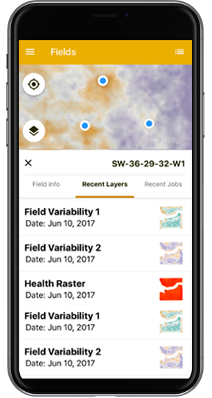
Easy-to-read Crop Health Maps enable and enhance agronomic decisions. Timely Scouting Maps allow you to monitor both subtle and major variations in vegetation and soil across your fields. You can take these maps on the go with our Scouting app.
Harvest Data
Our advanced analysis engine automatically cleans yield data, fills missing swaths and provides post-harvest calibration across multiple combines. Additional map layers, including elevation, moisture and productivity, are also available to help you plan and review your harvest.
Benchmarking Analytics & Reports
With tens of thousands of fields in our database, you can measure the relative yield of hybrids and varieties grown on your farm and within up to 800 kilometers of your region.
Predictive Modeling
Farmers Edge applies analytics to all data to form predictive models and valuable insights. The following models are currently available: Crop Growth Stages, Pests Modeling, Nitrogen & Yield Modeling.
WE HELP YOU GROW - TURN DATA INTO PROFIT
With many of our employees also being farmers, we know the value of reliable, trustworthy advice. That’s why we take pride in helping our growers every step of the way.
GROW WITH FARMERS EDGE
Pricing Options
Smart Imagery
$1.50/per acre 1 Year Commitment
FarmCommandTM Scouting Maps 1 & 2 Crop Health Maps